Lava Lamp Geology
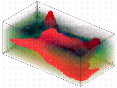
The volume shown in this figure is a representation of P-wave seismic velocities underlying the area of a small 3-D seismic survey in the Gulf of Mexico. The volume size is approximately 9 km by 6 km by 5 km (in depth). Buried salt bodies (interpreted from the seismic data) were assigned velocities of 4500 m/s and are shown in red. The surrounding sediments have velocities ranging from 1700 m/s to 3000 m/s and have been made mostly transparent in this display. If the salt structure in the foreground was unearthed and placed in Colorado Springs next to the Front Range Mountains, it would be about 1.5 times taller than Pike's Peak.
Many of today's major sedimentary basins had restricted access to the sea when they first opened. As a result, large quantities of salt were deposited in these basins during their early formation. (Imagine the Mediterranean Sea drying up if the Strait of Gibraltar was dammed.)* As these basins matured and filled with clastic sediments over millions of years, the oldest, bottom-most sediments became progressively more compacted by the overburden. Salt, however, is incompressible. It has a density of 2.2 gm/cc, which is intermediate between the density of clastic sediments at deposition and after full compaction. Because of the salt's position near the very bottom of these basins, density inversions developed, leading to large scale salt diapirism. This "lava lamp geology" produced severe deformation of the surrounding sedimentary strata.
Salt diapirism is important in the energy industry because when salt deforms adjacent clastic sediments, it creates structures that trap pools of hydrocarbons. Salt diapirs are frequently easy to recognize in seismic images because of the strong acoustic impedance contrast typical of the top of salt interface, and because of their distinctive three-dimensional geometries. However, these distinctive characteristics make salt imaging one of the most difficult problems in exploration seismology. A primary motivation in the adoption of 3-D seismic methods was a desire to improve seismic imaging around these bodies. More recently, the goal of imaging sediments under salt bodies has been the primary driver in developing prestack depth migration processing. But even when good seismic imaging is achieved, the turbulent structural history of salt diapirism can make interpretation a challenging exercise.
* [When I first linked to this Britannica article, it was available for free. It is still available at the same URL, but now Britannica is a pay site. It is an interesting read, but I'm sure most people will not go to the trouble of buying it. So that I don't leave readers with the wrong impression, I would like to point out that current thinking is that the Mediterranean Sea didn't actually dry up -- the salt crystalized out of solution.]
